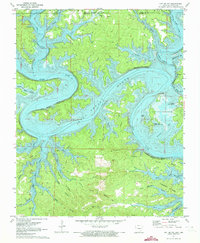
1972 Map of Cotter NW
USGS Topo · Published 1973About this map
Bull Shoals Lake dominates the landscape at the border of Arkansas and Missouri, its shoreline winding through the deeply etched valleys of the Ozarks. While the White River follows its ancient course through Cane Bottom Bluff and Bull Bottom Bluff, the impoundment of the lake by 1972 had already reshaped the local geography, creating recreational points like the Ozark Isle Public Use Area and Oakland Public Use Area.
Find a feature on this map
44 named features on this map. Tap any name to fly to it.
Don’t see what you’re looking for? This feature index may not catch every label — zoom into the map to look around manually.
Map Details
Editions of this 1972 Cotter NW Map
2 editions found
Other maps of this area

1893 · Yellville
USGS Topo · 1:125,000

1903 · Yellville
USGS Topo · 1:125,000

1905 · Yellville
USGS Topo · 1:125,000

1929 · Yellville
USGS Topo · 1:125,000

1936 · Thornfield
USGS Topo · 1:48,000

1943 · Protem
USGS Topo · 1:62,500

1943 · Thornfield
USGS Topo · 1:62,500

1945 · Harrison
USGS Topo · 1:250,000

1945 · Thornfield
USGS Topo · 1:62,500

1949 · Harrison
USGS Topo · 1:250,000