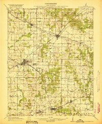
1917 Map of Coulterville
USGS Topo · Published 1917About this map
Coulterville and Sparta anchor this 1917 portrait of southern Illinois, revealing a landscape defined by its rural school districts and extensive rail infrastructure. The map depicts a period when one-room schoolhouses like Scotland School, Gravel Hill School, and Lost Prairie School were the heart of local communities, spaced evenly across the prairie. The region's development was driven by a dense network of railroads, including the Illinois Central and the Mobile and Ohio, which intersected at strategic junctions to serve the agricultural and burgeoning industrial needs of the county. From the open expanses of Grande Cote Prairie to the drainage basins of Marys River and Galum Creek, the survey captures the transition from pioneer-era settlement to an established rail-dependent economy. Notable local sites like The Lake near Coulterville and the small settlement of Kampenville provide specific points of interest for local history and genealogy research.
Find a feature on this map
76 named features on this map. Tap any name to fly to it.
Don’t see what you’re looking for? This feature index may not catch every label — zoom into the map to look around manually.
Map Details
Editions of this 1917 Coulterville Map
3 editions found
Other maps of this area

1910 · Murphysboro
USGS Topo · 1:62,500

1910 · Okawville
USGS Topo · 1:62,500

1912 · New Athens
USGS Topo · 1:62,500

1912 · Baldwin
USGS Topo · 1:62,500

1914 · Baldwin
USGS Topo · 1:62,500

1914 · Coulterville
USGS Topo · 1:62,500

1915 · Chester
USGS Topo · 1:62,500

1916 · Campbell Hill
USGS Topo · 1:62,500

1917 · Coulterville
USGS Topo · 1:62,500

1918 · Campbell Hill
USGS Topo · 1:62,500