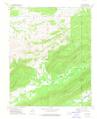
1973 Map of Counts
USGS Topo · Published 1975About this map
Counts serves as the central focal point for this survey of southeastern Oklahoma, situated near the intersection of several topographic valleys. The landscape is defined by the significant rise of Jackfork Mountain to the south and the Bolen Hollow State Public Hunting Area to the north, illustrating a region characterized by ridge-and-valley formations. The area is marked by a network of family and community landmarks, including several burial grounds such as Nace Cem, Burris Cem, and Weathers Cem, which indicate a long-standing pattern of rural settlement. Waterways like Jackfork Creek and Buffalo Creek drain these valleys, while a Landing Strip suggests the necessity of light aviation in this secluded terrain during the early 1970s. The convergence of three county lines—Pittsburg, Latimer, and Pushmataha—further defines the administrative character of this rural junction.
Find a feature on this map
30 named features on this map. Tap any name to fly to it.
Don’t see what you’re looking for? This feature index may not catch every label — zoom into the map to look around manually.
Map Details
Editions of this 1973 Counts Map
2 editions found
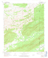
Other maps of this area

1898 · McAlester
USGS Topo · 1:125,000

1901 · Tuskahoma
USGS Topo · 1:125,000

1908 · Tuskahoma
USGS Topo · 1:125,000

1909 · Mc Alester
USGS Topo · 1:125,000

1909 · Tuskahoma
USGS Topo · 1:125,000

1950 · Mcalester
USGS Topo · 1:250,000

1962 · McAlester
USGS Topo · 1:250,000

1965 · McAlester
USGS Topo · 1:250,000

1967 · Hartshorne SW
USGS Topo · 1:24,000

1967 · Hartshorne
USGS Topo · 1:24,000