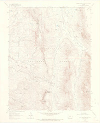
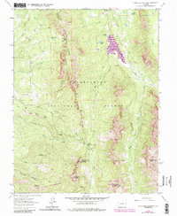
1963 Map of Courthouse Mountain
USGS Topo · Published 1970About this map
Cimarron Ridge serves as the backbone of this high-elevation landscape, where the headwaters of the West Fork Cimarron River and its siblings carve deep drainage patterns through the Uncompahgre National Forest. This 1963 survey captures a transitional era of land management and extraction, documenting the remote Kennedy Mine and the Jackson Guard Station as lonely outposts of human activity. The map reveals the critical mountain crossings of the day, specifically Owl Creek Pass and Lou Creek Pass, which provided essential navigation through the complex terrain of High Mesa and Spruce Ridge. Local landmarks like the distinctive Chimney Rock and named peaks such as Courthouse Mountain and Sneva Mountain anchor the topography, while unusual place names like the Cabbage Patch offer clues into the unique cultural geography of this alpine region.
Find a feature on this map
33 named features on this map. Tap any name to fly to it.
Don’t see what you’re looking for? This feature index may not catch every label — zoom into the map to look around manually.
Map Details
Editions of this 1963 Courthouse Mountain Map
5 editions found
Other maps of this area

1902 · Ouray
USGS Topo · 1:62,500

1903 · Lake City
USGS Topo · 1:62,500

1904 · Ouray
USGS Topo · 1:62,500

1905 · Lake City
USGS Topo · 1:62,500

1908 · Uncompahgre
USGS Topo · 1:125,000

1909 · Montrose
USGS Topo · 1:125,000

1911 · Uncompahgre
USGS Topo · 1:125,000

1911 · Montrose
USGS Topo · 1:125,000

1955 · Ouray
USGS Topo · 1:24,000

1956 · Montrose
USGS Topo · 1:250,000