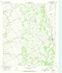
1966 Map of Covington
USGS Topo · Published 1968About this map
The Johnson Co Hill Co border cuts across this 1960s landscape, revealing a rural Texas interior defined by small farming settlements and natural drainages. Covington stands as the primary hub in the east, supported by local institutions like St Johns Ch and the High Sch. To the northwest, the town of Rio Vista sits near the upper reaches of Mustang Creek, while the smaller communities of Parker, Derden, and Woodrow are connected by a network of light-duty roads and an Old Railroad Grade that traces the eastern hills. This period shows a transition from traditional agrarian layouts to modern infrastructure, evidenced by the large Pipeline corridors and a prominent Pumping Sta near Darr Branch. Numerous family-named landmarks, such as Hart Cem, Kinard Cem, and Ross Cem, provide significant data for genealogical research into the families who established these Hill County outposts.
Find a feature on this map
25 named features on this map. Tap any name to fly to it.
Don’t see what you’re looking for? This feature index may not catch every label — zoom into the map to look around manually.
Map Details
Editions of this 1966 Covington Map
2 editions found
Other maps of this area

1891 · Cleburne
USGS Topo · 1:125,000

1894 · Cleburne
USGS Topo · 1:125,000

1924 · Cleburne 3-B
USGS Topo · 1:48,000

1924 · Cleburne 3-C
USGS Topo · 1:48,000

1927 · Blum
USGS Topo · 1:62,500

1954 · Dallas
USGS Topo · 1:250,000

1958 · Dallas
USGS Topo · 1:250,000

1960 · Cleburne East
USGS Topo · 1:24,000
1961 · Cleburne West
USGS Topo · 1:24,000
1961 · Grandview
USGS Topo · 1:24,000