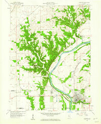
1958 Map of Covington
USGS Topo · Published 1980About this map
The Wabash River dominates this landscape, serving as a historic county line and an industrial corridor for western Indiana in the late 1950s. The town of Covington sits on the eastern bank, showing a grid of streets and a concentration of civic infrastructure near the Mallory Branch. The map traces the vestigial path of the Erie and Wabash Canal as it parallels the river, a reminder of an earlier transportation era that preceded the New York Central rail lines shown cutting through Foster and Johnsonville. Numerous rural burial grounds, including Gopher Hill Cem, Baltimore Cem, and Rogers Cem, are scattered across the surrounding townships of Kent and Steuben. This survey documents a transition in land use, from the dense topography of Hills and Coal Hollow to the established agricultural plains marked by the Galloway Chapel and Benson Chapel.
Find a feature on this map
38 named features on this map. Tap any name to fly to it.
Don’t see what you’re looking for? This feature index may not catch every label — zoom into the map to look around manually.
Map Details
Editions of this 1958 Covington Map
4 editions found
Other maps of this area

1899 · Danville
USGS Topo · 1:62,500

1900 · Danville
USGS Topo · 1:62,500

1933 · Hoopeston
USGS Topo · 1:48,000

1938 · Hoopeston
USGS Topo · 1:62,500

1950 · Danville SE
USGS Topo · 1:24,000

1950 · Danville NE
USGS Topo · 1:24,000

1951 · Danville NE
USGS Topo · 1:24,000

1951 · Danville SE
USGS Topo · 1:24,000

1953 · Danville
USGS Topo · 1:250,000

1955 · Danville
USGS Topo · 1:250,000