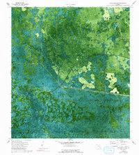
1974 Map of Cow Bone Island
USGS Topo · Published 1993About this map
The Seminole Indian Reservation occupies a significant portion of this southern Florida landscape, where the natural hydrology of the Big Cypress region is clearly visible through an orthophotomap perspective. This hybrid document combines aerial imagery with topographic data, revealing the intricate patterns of cypress strands like Tony Strand and Cow Bell Strand. The drainage and water management of the mid-1970s is evidenced by the prominent West Canal cutting through the terrain and the proximity of Lard Can Slough. Notable landforms such as Cow Bone Island rise above the surrounding wetlands, providing insight into the subtle elevation changes that dictate the area's ecology. Small-scale development, including a Radio Tower, appears as isolated markers within the expansive natural system, showing the early stages of infrastructure reaching into this corner of the Florida interior.
Find a feature on this map
12 named features on this map. Tap any name to fly to it.
Don’t see what you’re looking for? This feature index may not catch every label — zoom into the map to look around manually.
Map Details
Editions of this 1974 Cow Bone Island Map
3 editions found
Other maps of this area

1956 · West Palm Beach
USGS Topo · 1:250,000

1957 · West Palm Beach
USGS Topo · 1:250,000

1958 · West Palm Beach
USGS Topo · 1:250,000

1974 · Everglades 2 SW
USGS Topo · 1:24,000

1974 · Immokalee 4 NW
USGS Topo · 1:24,000

1974 · Immokalee 1 SW
USGS Topo · 1:24,000

1974 · Immokalee 1 SE
USGS Topo · 1:24,000

1974 · Immokalee 1 NE
USGS Topo · 1:24,000
1974 · Everglades 2 NW
USGS Topo · 1:24,000
1974 · Immokalee 4 NE
USGS Topo · 1:24,000