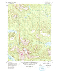
1949 Map of Craig C-3
USGS Topo · Published 1983About this map
Prince of Wales Island is documented here through a multi-decade lens, combining 1948 aerial photography with 1985 updates to track the evolving landscape of the Tongass National Forest. The interior is defined by significant freshwater systems including Black Bear Lake and the winding course of the Thorne River, which flows through the northern reaches of the quadrangle. In the south, the presence of the Lucky Nell Mine (Inactive) near the Harris River points to the region's historical mineral exploration and resource extraction history.
Find a feature on this map
21 named features on this map. Tap any name to fly to it.
Don’t see what you’re looking for? This feature index may not catch every label — zoom into the map to look around manually.
Map Details
Editions of this 1949 Craig C-3 Map
4 editions found
Other maps of this area

1949 · Craig D-3
USGS Topo · 1:63,360

1949 · Craig C-2
USGS Topo · 1:63,360

1949 · Craig D-2
USGS Topo · 1:63,360

1949 · Craig B-2
USGS Topo · 1:63,360

1949 · Craig D-4
USGS Topo · 1:63,360

1949 · Craig B-3
USGS Topo · 1:63,360

1949 · Craig C-3
USGS Topo · 1:63,360

1949 · Craig C-4
USGS Topo · 1:63,360

1949 · Craig B-4
USGS Topo · 1:63,360

1950 · Craig D-3
USGS Topo · 1:63,360