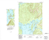
1949 Map of Craig C-4
USGS Topo · Published 1988About this map
Klawock sits at the center of this coastal landscape on Prince of Wales Island, serving as a focal point for the region's maritime and industrial activity in the mid-20th century. The intricate shoreline of Klawock Inlet and Shinaku Inlet is marked by essential local infrastructure, including a Fish Hatchery near the mouth of the Klawock River and a Quarry just south of the main settlement. The geography here is a complex network of islands and waterways, where Peratrovich Island and Wadleigh Island shield the harbor from the more open waters of San Alberto Bay.
Find a feature on this map
54 named features on this map. Tap any name to fly to it.
Don’t see what you’re looking for? This feature index may not catch every label — zoom into the map to look around manually.
Map Details
Editions of this 1949 Craig C-4 Map
5 editions found
Other maps of this area

1948 · Craig B-5
USGS Topo · 1:63,360

1949 · Craig D-3
USGS Topo · 1:63,360

1949 · Craig D-4
USGS Topo · 1:63,360

1949 · Craig B-3
USGS Topo · 1:63,360

1949 · Craig C-3
USGS Topo · 1:63,360

1949 · Craig C-4
USGS Topo · 1:63,360

1949 · Craig B-4
USGS Topo · 1:63,360

1950 · Craig D-3
USGS Topo · 1:63,360

1951 · Craig C-3
USGS Topo · 1:63,360

1951 · Craig B-4
USGS Topo · 1:63,360