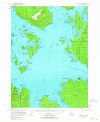
1951 Map of Craig C-5
USGS Topo · Published 1964About this map
The coastal intricacies of the Tongass National Forest are captured here as they appeared in the early 1950s. This survey focuses on the maritime landscape of Prince of Wales Island and the surrounding Alexander Archipelago. Small shorefront outposts like Bobs Place mark the infrequent human footprint among a complex network of channels and passages. The map illustrates the region's reliance on water-based travel and subsistence, charting numerous islands such as Heceta Island, Noyes Island, and San Fernando Island. Because this terrain was primarily accessed by sea, the mapping includes significant hydrographic detail and shoreline annotations including Nossuk Bay and the Gulf of Esquibel. This record preserves the location of isolated camps and landmarks in a period when aerial photography was beginning to provide the first comprehensive view of Alaska's rugged panhandle.
Find a feature on this map
2 named features on this map. Tap any name to fly to it.
Don’t see what you’re looking for? This feature index may not catch every label — zoom into the map to look around manually.
Map Details
Editions of this 1951 Craig C-5 Map
5 editions found
Other maps of this area

1948 · Craig B-5
USGS Topo · 1:63,360

1948 · Craig B-6
USGS Topo · 1:63,360

1949 · Craig D-4
USGS Topo · 1:63,360

1949 · Craig C-4
USGS Topo · 1:63,360

1949 · Craig B-4
USGS Topo · 1:63,360

1951 · Craig C-6
USGS Topo · 1:63,360

1951 · Craig D-6
USGS Topo · 1:63,360

1951 · Craig B-4
USGS Topo · 1:63,360

1951 · Craig C-4
USGS Topo · 1:63,360

1951 · Craig C-5
USGS Topo · 1:63,360