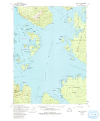
1951 Map of Craig C-5
USGS Topo · Published 1993About this map
Heceta Island and the intricate archipelago of the Maurelle Islands Wilderness dominate this coastal survey, which integrates aerial photography from 1948 and 1984. The landscape is defined by its maritime infrastructure, featuring a Seaplane Base and Cannery at Steamboat Bay, reflecting the mid-century reliance on air and water transport in Southeast Alaska. Coastal navigation is guided by numerous named points and reefs, such as Pt Desconocida and Desconocida Reef, while the interior terrain rises toward Bald Mtn and Timber Knob. Cultural markers like Haida Camp and the archaeological note at Hole in the Wall provide evidence of human presence throughout these waterways. The map also records small seasonal or historical settlements such as Bobs Place, often associated with the fishing and canning industries that once thrived along the Gulf of Esquibel.
Find a feature on this map
77 named features on this map. Tap any name to fly to it.
Don’t see what you’re looking for? This feature index may not catch every label — zoom into the map to look around manually.
Map Details
Editions of this 1951 Craig C-5 Map
5 editions found
Other maps of this area

1948 · Craig B-5
USGS Topo · 1:63,360

1948 · Craig B-6
USGS Topo · 1:63,360

1949 · Craig D-4
USGS Topo · 1:63,360

1949 · Craig C-4
USGS Topo · 1:63,360

1949 · Craig B-4
USGS Topo · 1:63,360

1951 · Craig C-6
USGS Topo · 1:63,360

1951 · Craig D-6
USGS Topo · 1:63,360

1951 · Craig B-4
USGS Topo · 1:63,360

1951 · Craig C-4
USGS Topo · 1:63,360

1951 · Craig C-5
USGS Topo · 1:63,360