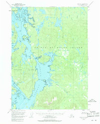
1949 Map of Craig D-4
USGS Topo · Published 1971About this map
El Capitan Passage and Tuxekan Passage dominate this coastal landscape of the Alexander Archipelago, where the complex waterways of Prince of Wales Island and Tuxekan Island meet. This mid-century survey documents a transitional era for local settlements, explicitly marking both Deweyville and Tuxekan as abandoned. The presence of a Seaplane Base at New Tokeen highlights the continued reliance on air and sea travel for connectivity in this roadless portion of the Tongass National Forest. Inland, the map reveals a network of salmon-bearing waters including Sarkar Lake, Sarkar Rapids, and Silver Salmon Falls on Staney Creek. From the heights of Twin Mtn to the tidal complexity of Skookumchuck, the map provides a precise record of the shoreline and maritime hazards like Hub Rk and Lte Peep Rk during the late 1940s.
Find a feature on this map
68 named features on this map. Tap any name to fly to it.
Don’t see what you’re looking for? This feature index may not catch every label — zoom into the map to look around manually.
Map Details
Editions of this 1949 Craig D-4 Map
3 editions found
Other maps of this area

1949 · Craig D-3
USGS Topo · 1:63,360

1949 · Petersburg A-3
USGS Topo · 1:63,360

1949 · Craig D-4
USGS Topo · 1:63,360

1949 · Petersburg A-5
USGS Topo · 1:63,360

1949 · Petersburg A-4
USGS Topo · 1:63,360

1949 · Craig C-3
USGS Topo · 1:63,360

1949 · Craig C-4
USGS Topo · 1:63,360

1950 · Craig D-3
USGS Topo · 1:63,360

1951 · Craig C-3
USGS Topo · 1:63,360

1951 · Craig C-4
USGS Topo · 1:63,360