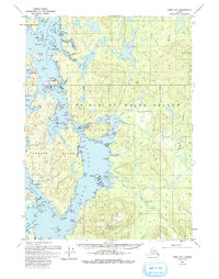
1949 Map of Craig D-4
USGS Topo · Published 1993About this map
Prince of Wales Island dominates this coastal survey, where the intricate maritime geography of Southeast Alaska is defined by a network of inlets, narrows, and islands. In the mid-twentieth century, human activity in this corner of the Tongass National Forest is evidenced by the Nichin Cove Seaplane Base and legacy locations such as the Deweyville and Tuxekan sites. The coastline is fragmented by significant waterways like Tuxekan Narrows and Tuxekan Passage, separating the main landmass from Tuxekan Island and El Capitan Island. Inland, the terrain rises toward peaks like Twin Mtn, with a dense drainage system including Sarkar Creek and Staney Creek feeding into the Pacific. The presence of Graveyard Island and Sarkar Rapids points to the long-standing navigational and cultural importance of these sheltered passages before modern development altered the region's accessibility.
Find a feature on this map
65 named features on this map. Tap any name to fly to it.
Don’t see what you’re looking for? This feature index may not catch every label — zoom into the map to look around manually.
Map Details
Editions of this 1949 Craig D-4 Map
3 editions found
Other maps of this area

1949 · Craig D-3
USGS Topo · 1:63,360

1949 · Petersburg A-3
USGS Topo · 1:63,360

1949 · Craig D-4
USGS Topo · 1:63,360

1949 · Petersburg A-5
USGS Topo · 1:63,360

1949 · Petersburg A-4
USGS Topo · 1:63,360

1949 · Craig C-3
USGS Topo · 1:63,360

1949 · Craig C-4
USGS Topo · 1:63,360

1950 · Craig D-3
USGS Topo · 1:63,360

1951 · Craig C-3
USGS Topo · 1:63,360

1951 · Craig C-4
USGS Topo · 1:63,360