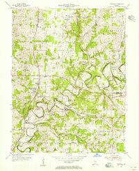
1954 Map of Crandall
USGS Topo · Published 1971About this map
Big Indian Creek meanders through the heart of this southern Indiana landscape, carving a deep valley that dictates the region's transport and settlement patterns during the mid-1950s. The Southern railroad follows the contours of the creek valley, serving vital local hubs like Crandall, Mott Station, and the dual-named Corydon Junction (New Salisbury P O). This network supported a rural economy punctuated by numerous country churches and cemeteries that remain essential for genealogical research, including the Old German Ch and Bethlehem Cem. On the higher ground between the creek's loops, small crossroads communities like New Salisbury and Central Barren established local schools and social centers, such as the High Sch and the Floyd County Conservation Club. The map provides a detailed view of the transition from the rolling uplands of Morgan and Jackson townships down to the fertile river bottomlands.
Find a feature on this map
39 named features on this map. Tap any name to fly to it.
Don’t see what you’re looking for? This feature index may not catch every label — zoom into the map to look around manually.
Map Details
Editions of this 1954 Crandall Map
4 editions found
Other maps of this area

1909 · Kosmosdale
USGS Topo · 1:48,000

1912 · Kosmosdale
USGS Topo · 1:62,500

1931 · Corydon
USGS Topo · 1:62,500

1939 · Georgetown
USGS Topo · 1:24,000

1941 · Borden
USGS Topo · 1:24,000

1944 · Corydon West
USGS Topo · 1:24,000

1946 · Depauw
USGS Topo · 1:24,000

1947 · Georgetown
USGS Topo · 1:24,000

1947 · Corydon West
USGS Topo · 1:24,000

1948 · Corydon East
USGS Topo · 1:24,000