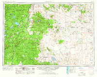
1955 Map of Crescent
USGS Topo · Published 1966About this map
The Southern Pacific and Great Northern railroads anchor the central Oregon corridor in the mid-1950s, cutting through a landscape dominated by volcanic geology and protected timberlands. The convergence of Deschutes National Forest, Winema National Forest, and Fremont National Forest highlights the region's importance to the timber industry, with the company town of Gilchrist serving as a primary settlement. To the east, the terrain shifts dramatically from the high forest into the arid basins of Fort Rock Valley and Christmas Lake Valley, where small outposts like Stauffer and Hampton dot the sagebrush plains.
Find a feature on this map
137 named features on this map. Tap any name to fly to it.
Don’t see what you’re looking for? This feature index may not catch every label — zoom into the map to look around manually.
Map Details
Editions of this 1955 Crescent Map
3 editions found

Other maps of this area

1889 · Klamath
USGS Topo · 1:250,000

1891 · Ashland
USGS Topo · 1:250,000

1893 · Ashland
USGS Topo · 1:250,000

1894 · Klamath
USGS Topo · 1:250,000

1897 · Ashland
USGS Topo · 1:250,000

1917 · Diamond Lake
USGS Topo · 1:125,000

1925 · Waldo Lake
USGS Topo · 1:125,000

1926 · Bend
USGS Topo · 1:125,000

1929 · Bend
USGS Topo · 1:125,000

1929 · Three Sisters
USGS Topo · 1:125,000