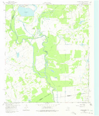
1960 Map of Creslenn Ranch
USGS Topo · Published 1975About this map
The Trinity River winds through this landscape on the border of Henderson and Navarro Counties, defining a region shaped by complex hydrology and large-scale ranching. The Creslenn Ranch (Headquarters) and its associated Creslenn Park sit near the center of the sheet, where The Cutoff and several oxbow lakes like Morrison Lake and Stephens Lake indicate the river's historical shifts. To the north, Trinidad Lake and the settlement of Trinidad mark the edge of more developed industrial and residential activity.
Find a feature on this map
37 named features on this map. Tap any name to fly to it.
Don’t see what you’re looking for? This feature index may not catch every label — zoom into the map to look around manually.
Map Details
Editions of this 1960 Creslenn Ranch Map

Other maps of this area

1949 · Athens
USGS Topo · 1:62,500

1949 · Tennessee Colony
USGS Topo · 1:62,500

1950 · Athens
USGS Topo · 1:62,500

1950 · Tennessee Colony
USGS Topo · 1:62,500

1953 · Palestine
USGS Topo · 1:250,000

1954 · Dallas
USGS Topo · 1:250,000

1954 · Waco
USGS Topo · 1:250,000

1955 · Waco
USGS Topo · 1:250,000

1956 · Tyler
USGS Topo · 1:250,000

1957 · Palestine
USGS Topo · 1:250,000