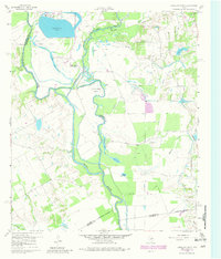
1960 Map of Creslenn Ranch
USGS Topo · Published 1981About this map
Trinity River oxbows and bottomlands define this East Texas landscape at the junction of Henderson, Navarro, and Anderson counties. The 1960 topography, updated with 1981 photogrammetric revisions, highlights the significant hydrological management of the era, including the The Cutoff and the sprawling Trinidad Lake in the northwest corner. This is a region shaped by both large-scale ranching and the petroleum industry, centered on the Creslenn Ranch Headquarters.
Find a feature on this map
29 named features on this map. Tap any name to fly to it.
Don’t see what you’re looking for? This feature index may not catch every label — zoom into the map to look around manually.
Map Details
Editions of this 1960 Creslenn Ranch Map

Other maps of this area

1949 · Athens
USGS Topo · 1:62,500

1949 · Tennessee Colony
USGS Topo · 1:62,500

1950 · Athens
USGS Topo · 1:62,500

1950 · Tennessee Colony
USGS Topo · 1:62,500

1953 · Palestine
USGS Topo · 1:250,000

1954 · Dallas
USGS Topo · 1:250,000

1954 · Waco
USGS Topo · 1:250,000

1955 · Waco
USGS Topo · 1:250,000

1956 · Tyler
USGS Topo · 1:250,000

1957 · Palestine
USGS Topo · 1:250,000