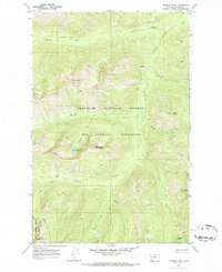
1970 Map of Crimson Peak
USGS Topo · Published 1973About this map
The Bob Marshall Wilderness forms the core of this 1970s survey, illustrating a landscape defined by high ridgelines and essential backcountry routes. The topography is dominated by the Crimson Peak massif, which rises above the small Crimson Lake, and various other summits including Goat Mtn and Puma Peak. The map records a complex drainage system where Babcock Creek and Youngs Creek carve through the deep valleys of the Flathead National Forest. This era of mapping emphasizes the primitive transportation network of the high country, specifically the Pack Trail segments and the Blackfoot Divide Trail (Pack) that provided the only access through these protected lands. At the southern margin, the boundary transition to the Lolo National Forest is noted near Devine Peak.
Find a feature on this map
29 named features on this map. Tap any name to fly to it.
Don’t see what you’re looking for? This feature index may not catch every label — zoom into the map to look around manually.
Map Details
Editions of this 1970 Crimson Peak Map
2 editions found
Other maps of this area

1902 · Ovando
USGS Topo · 1:125,000

1905 · Ovando
USGS Topo · 1:125,000

1955 · Choteau
USGS Topo · 1:250,000

1957 · Choteau
USGS Topo · 1:250,000

1958 · Choteau
USGS Topo · 1:250,000

1962 · Choteau
USGS Topo · 1:250,000

1965 · Morrell Mountain
USGS Topo · 1:24,000
1965 · Seeley Lake East
USGS Topo · 1:24,000

1968 · Dunham Point
USGS Topo · 1:24,000
1970 · Crimson Peak
USGS Topo · 1:24,000