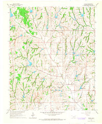
1966 Map of Criner
USGS Topo · Published 1967About this map
The Oklahoma prairie of McClain County is defined here by a network of petroleum extraction sites and small agricultural crossroads during the mid-1960s. The Northeast Criner Oil Field and Southwest Criner Oil Field dominate the landscape, with numerous wells and access roads tracing the subterranean wealth of the Colbert and Turnbull townships. The tiny settlement of Criner serves as a central point, while the local community life is anchored by landmarks like Bryant Ch near the eastern border.
Find a feature on this map
16 named features on this map. Tap any name to fly to it.
Don’t see what you’re looking for? This feature index may not catch every label — zoom into the map to look around manually.
Map Details
Editions of this 1966 Criner Map
3 editions found
Other maps of this area

1893 · Norman
USGS Topo · 1:62,500

1898 · Purcell
USGS Topo · 1:125,000

1898 · Pauls Valley
USGS Topo · 1:125,000

1902 · Pauls Valley
USGS Topo · 1:125,000

1902 · Rush Springs
USGS Topo · 1:125,000

1904 · Chickasha
USGS Topo · 1:125,000

1936 · Norman
USGS Topo · 1:62,500

1954 · Oklahoma City
USGS Topo · 1:250,000

1957 · Ardmore
USGS Topo · 1:250,000

1957 · Oklahoma City
USGS Topo · 1:250,000