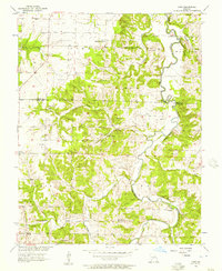
1956 Map of Crisp
USGS Topo · Published 1957About this map
Sac River and its winding tributaries, including Mutton Creek and Sons Creek, define the landscape of this mid-1950s rural Missouri study. The topography is marked by distinctive bluffs such as Ruark Bluff, Wasson Bluff, and Sorters Bluff, which overlook the river's path through Madison and Sac townships. Small rural centers like Crisp and Seybert serve as anchors for a community deeply rooted in its local geography.
Find a feature on this map
34 named features on this map. Tap any name to fly to it.
Don’t see what you’re looking for? This feature index may not catch every label — zoom into the map to look around manually.
Map Details
Editions of this 1956 Crisp Map
3 editions found
Other maps of this area

1886 · Stockton
USGS Topo · 1:125,000

1886 · Greenfield
USGS Topo · 1:125,000

1888 · Greenfield
USGS Topo · 1:125,000

1954 · Springfield
USGS Topo · 1:250,000

1955 · Dadeville
USGS Topo · 1:24,000
1956 · Stockton
USGS Topo · 1:24,000
1956 · Bearcreek
USGS Topo · 1:24,000

1956 · Greenfield
USGS Topo · 1:24,000
1956 · Lockwood
USGS Topo · 1:24,000
1956 · Bona
USGS Topo · 1:24,000