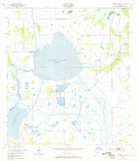
1953 Map of Cypress Lake
USGS Topo · Published 1968About this map
Cypress Lake dominates this Central Florida landscape, positioned at the critical boundary of Osceola and Polk Counties in the early 1950s. The map illustrates a complex hydraulic network of natural waterways and mid-century engineered improvements, including the South Port Canal and Hatchineha Canal. These connections linked the major water bodies of Lake Gentry and Lake Hatchineha, reflecting the region's efforts to manage the vast marshlands for drainage and navigation.
Find a feature on this map
20 named features on this map. Tap any name to fly to it.
Don’t see what you’re looking for? This feature index may not catch every label — zoom into the map to look around manually.
Map Details
Editions of this 1953 Cypress Lake Map
4 editions found
Other maps of this area

1952 · Lake Weohyakapka NE
USGS Topo · 1:24,000

1952 · Hesperides
USGS Topo · 1:24,000

1953 · Lake Marian NW
USGS Topo · 1:24,000

1953 · Cypress Lake
USGS Topo · 1:24,000

1953 · Lake Hatchineha
USGS Topo · 1:24,000

1953 · St Cloud South
USGS Topo · 1:24,000

1953 · Lake Tohopekaliga
USGS Topo · 1:24,000

1953 · Holopaw SW
USGS Topo · 1:24,000

1953 · Ashton
USGS Topo · 1:24,000

1955 · Orlando
USGS Topo · 1:250,000