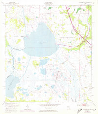
1953 Map of Cypress Lake
USGS Topo · Published 1972About this map
Cypress Lake dominates this central Florida landscape, sitting at the junction of Osceola and Polk counties. This 1950s survey, with 1970 photorevised updates, illustrates a complex hydrological system of natural waterways and man-made infrastructure. The Floridas Turnpike Toll Road cuts through the eastern portion of the sheet, signaling the era of modern transportation expansion.
Find a feature on this map
21 named features on this map. Tap any name to fly to it.
Don’t see what you’re looking for? This feature index may not catch every label — zoom into the map to look around manually.
Map Details
Editions of this 1953 Cypress Lake Map
4 editions found
Other maps of this area

1952 · Lake Weohyakapka NE
USGS Topo · 1:24,000

1952 · Hesperides
USGS Topo · 1:24,000

1953 · Lake Marian NW
USGS Topo · 1:24,000

1953 · Cypress Lake
USGS Topo · 1:24,000

1953 · Lake Hatchineha
USGS Topo · 1:24,000

1953 · St Cloud South
USGS Topo · 1:24,000

1953 · Lake Tohopekaliga
USGS Topo · 1:24,000

1953 · Holopaw SW
USGS Topo · 1:24,000

1953 · Ashton
USGS Topo · 1:24,000

1955 · Orlando
USGS Topo · 1:250,000