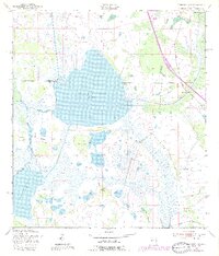
1953 Map of Cypress Lake
USGS Topo · Published 1987About this map
The lowlands of the Osceola and Polk county line are defined by a complex network of wetlands and managed waterways centered on Cypress Lake. This 1953 survey, updated in the late 1980s, illustrates the hydrological connectivity between Lake Hatchineha and smaller bodies like Lake Gentry through a series of engineered passages including the South Port Canal and Hatchineha Canal. The interior terrain is characterized by numerous "hammocks"—islands of dense vegetation amidst the marsh—bearing local names such as Ike Hammock, Carson Hammock, and Coon Hammock. These features, along with larger landmasses like Johnson Island and Rough Island, provide critical context for understanding historical land use and cattle ranching patterns in the Florida interior. The presence of Florida's Turnpike Toll Road cutting across the eastern portion of the sheet marks the arrival of modern infrastructure through this traditional wet prairie landscape.
Find a feature on this map
22 named features on this map. Tap any name to fly to it.
Don’t see what you’re looking for? This feature index may not catch every label — zoom into the map to look around manually.
Map Details
Editions of this 1953 Cypress Lake Map
4 editions found
Other maps of this area

1952 · Lake Weohyakapka NE
USGS Topo · 1:24,000

1952 · Hesperides
USGS Topo · 1:24,000

1953 · Lake Marian NW
USGS Topo · 1:24,000

1953 · Cypress Lake
USGS Topo · 1:24,000

1953 · Lake Hatchineha
USGS Topo · 1:24,000

1953 · St Cloud South
USGS Topo · 1:24,000

1953 · Lake Tohopekaliga
USGS Topo · 1:24,000

1953 · Holopaw SW
USGS Topo · 1:24,000

1953 · Ashton
USGS Topo · 1:24,000

1955 · Orlando
USGS Topo · 1:250,000