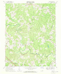
1968 Map of Dabneys
USGS Topo · Published 1970About this map
The South Anna River winds through this central Virginia landscape, defining a rural network of small communities and crossroads churches in the late 1960s. Settled points such as Holly Grove, Dabneys, and Shelfar are connected by narrow secondary roads that navigate the complex drainage systems of Owens and Taylors Creek. This area, straddling the boundaries of Louisa, Hanover, and Goochland counties, is characterized by its numerous historic congregations, including Hopeful Ch, Mt Olivet Ch, and Salem Ch.
Find a feature on this map
40 named features on this map. Tap any name to fly to it.
Don’t see what you’re looking for? This feature index may not catch every label — zoom into the map to look around manually.
Map Details
Editions of this 1968 Dabneys Map
3 editions found
Other maps of this area

1890 · Goochland
USGS Topo · 1:125,000

1892 · Goochland
USGS Topo · 1:125,000

1942 · Pendleton
USGS Topo · 1:24,000

1942 · Buckner
USGS Topo · 1:24,000

1942 · Beaverdam
USGS Topo · 1:24,000

1943 · Goochland
USGS Topo · 1:31,680

1943 · Mabelton
USGS Topo · 1:31,680

1943 · Perkinsville
USGS Topo · 1:31,680

1943 · Pendleton
USGS Topo · 1:31,680
1943 · Buckner
USGS Topo · 1:31,680