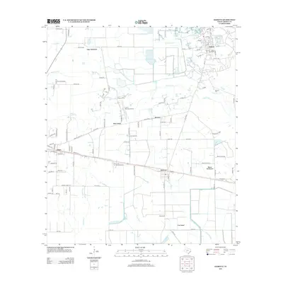
2013 Map of Daisetta
USGS Topo · Published 2013About this map
Frige Settlement and Moore Settlement anchor this Liberty County landscape, illustrating a classic Texas pattern of rural community clusters that persist alongside established towns. The area's transport infrastructure is defined by the intersection of rail and road, with the town of Daisetta situated in the northeast near W End Slough. To the west, the community of Ames is home to the Ames Cem, providing valuable data for local genealogists. The terrain is characterized by a dense network of waterways including Turtle Bayou, Whites Bayou, and Long Island Cr, which drain the low-lying prairie toward Cow Island. Aviation activity is prominent in this corridor, marked by both the Liberty Municipal Airport and the Tri-County Air Service Airport. Smaller settlements like Woodson and Raywood dot the transit lines, while the Oak Dale Cem sits tucked near the banks of Whites Bayou.
Find a feature on this map
113 named features on this map. Tap any name to fly to it.
Don’t see what you’re looking for? This feature index may not catch every label — zoom into the map to look around manually.
Map Details
Editions of this 2013 Daisetta Map
This is the sole edition of this map. No revisions or reprints were ever made.
Other maps of this area

1943 · Whites Bayou
USGS Topo · 1:24,000

1943 · Liberty
USGS Topo · 1:125,000

1950 · Houston
USGS Topo · 1:250,000

1954 · Beaumont
USGS Topo · 1:250,000

1955 · Daisetta
USGS Topo · 1:62,500

1955 · Liberty
USGS Topo · 1:62,500

1956 · Houston
USGS Topo · 1:250,000

1957 · Beaumont
USGS Topo · 1:250,000

1961 · Shiloh
USGS Topo · 1:24,000
1961 · Whites Bayou
USGS Topo · 1:24,000