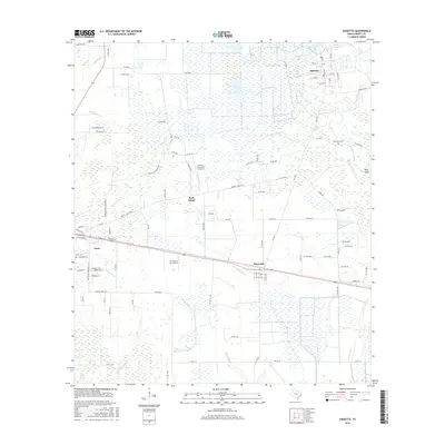
2016 Map of Daisetta
USGS Topo · Published 2016About this map
Daisetta and its surrounding wetlands dominate this coastal prairie landscape in Liberty County. The region is defined by a dense network of slow-moving waterways including Turtle Bayou, Cow Island Bayou, and the expansive Daisetta Swamp, which shape the local settlement patterns and infrastructure. Smaller residential clusters like Ames, Raywood, and the community at Rock Island are linked by rural routes such as Fregia Settlement Rd, suggesting a landscape still deeply tied to its original homesteads and topographic constraints.
Find a feature on this map
101 named features on this map. Tap any name to fly to it.
Don’t see what you’re looking for? This feature index may not catch every label — zoom into the map to look around manually.
Map Details
Editions of this 2016 Daisetta Map
This is the sole edition of this map. No revisions or reprints were ever made.
Other maps of this area

1943 · Whites Bayou
USGS Topo · 1:24,000

1943 · Liberty
USGS Topo · 1:125,000

1950 · Houston
USGS Topo · 1:250,000

1954 · Beaumont
USGS Topo · 1:250,000

1955 · Daisetta
USGS Topo · 1:62,500

1955 · Liberty
USGS Topo · 1:62,500

1956 · Houston
USGS Topo · 1:250,000

1957 · Beaumont
USGS Topo · 1:250,000

1961 · Shiloh
USGS Topo · 1:24,000
1961 · Whites Bayou
USGS Topo · 1:24,000