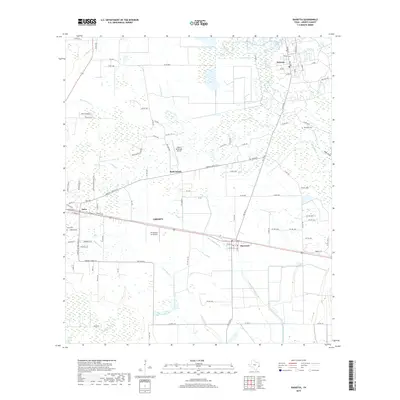
2019 Map of Daisetta
USGS Topo · Published 2019About this map
Low-lying coastal wetlands and small East Texas settlements define this landscape in Liberty County. The community of Daisetta sits at the edge of the Daisetta Swamp, where a network of local roads including FM 770 N and FM 834 E connect it to the surrounding bayous. The map captures the industrial and agricultural character of the region, featuring aviation hubs like Liberty Municipal Airport and Tri-County Air Service alongside the quiet rural centers of Ames and Raywood.
Find a feature on this map
102 named features on this map. Tap any name to fly to it.
Don’t see what you’re looking for? This feature index may not catch every label — zoom into the map to look around manually.
Map Details
Editions of this 2019 Daisetta Map
This is the sole edition of this map. No revisions or reprints were ever made.
Other maps of this area

1943 · Whites Bayou
USGS Topo · 1:24,000

1943 · Liberty
USGS Topo · 1:125,000

1950 · Houston
USGS Topo · 1:250,000

1954 · Beaumont
USGS Topo · 1:250,000

1955 · Daisetta
USGS Topo · 1:62,500

1955 · Liberty
USGS Topo · 1:62,500

1956 · Houston
USGS Topo · 1:250,000

1957 · Beaumont
USGS Topo · 1:250,000

1961 · Shiloh
USGS Topo · 1:24,000
1961 · Whites Bayou
USGS Topo · 1:24,000