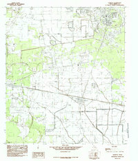
1984 Map of Daisetta
USGS Topo · Published 1985About this map
Oil and gas infrastructure dominates this 1984 survey of Liberty County, particularly surrounding the settlement of Daisetta. The landscape is a complex mix of industrial activity and low-lying wetlands, where an extensive network of pipelines and an Oil and Gas Field sit adjacent to features like Swamp and Long Island. Local life is anchored by several small towns including Hardin, Ames, and Raywood, each situated near the region's prominent drainage systems such as Abbott Creek and Turkey Creek Marsh. The map also records specialized land use, from the Liberty Municipal Airport to a local Rodeo Ground. This industrial and rural character is further reflected in features like the Spoil Bank, showing how human activity has physically altered the terrain to facilitate the energy economy of late 20th-century Texas.
Find a feature on this map
22 named features on this map. Tap any name to fly to it.
Don’t see what you’re looking for? This feature index may not catch every label — zoom into the map to look around manually.
Map Details
Editions of this 1984 Daisetta Map
This is the sole edition of this map. No revisions or reprints were ever made.
Other maps of this area

1943 · Whites Bayou
USGS Topo · 1:24,000

1943 · Liberty
USGS Topo · 1:125,000

1950 · Houston
USGS Topo · 1:250,000

1954 · Beaumont
USGS Topo · 1:250,000

1955 · Daisetta
USGS Topo · 1:62,500

1955 · Liberty
USGS Topo · 1:62,500

1956 · Houston
USGS Topo · 1:250,000

1957 · Beaumont
USGS Topo · 1:250,000

1961 · Shiloh
USGS Topo · 1:24,000
1961 · Whites Bayou
USGS Topo · 1:24,000