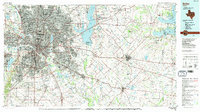
1986 Map of Dallas
USGS Topo · Published 1991About this map
The Trinity River and its managed flood control systems anchor the mid-1980s expansion of the Dallas-Fort Worth metroplex. This survey captures a period of intense suburban development stretching from Irving and Grand Prairie in the west toward Mesquite and Garland in the east. The landscape is defined by massive water management projects like Lake Ray Hubbard and the Dallas Floodway, which transformed the natural hydrology to support urban growth.
Find a feature on this map
196 named features on this map. Tap any name to fly to it.
Don’t see what you’re looking for? This feature index may not catch every label — zoom into the map to look around manually.
Map Details
Editions of this 1986 Dallas Map
3 editions found
Other maps of this area

1891 · Dallas
USGS Topo · 1:125,000

1891 · Cleburne
USGS Topo · 1:125,000

1893 · Dallas
USGS Topo · 1:125,000

1894 · Cleburne
USGS Topo · 1:125,000

1894 · Fort Worth
USGS Topo · 1:125,000

1912 · Rockwall
USGS Topo · 1:31,680

1919 · Royse City
USGS Topo · 1:62,500

1920 · Kemp
USGS Topo · 1:62,500

1924 · Farmersville 3-c
USGS Topo · 1:48,000

1924 · Mc Kinney 4-d
USGS Topo · 1:48,000