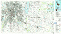
1986 Map of Dallas
USGS Topo · Published 1986About this map
Dallas serves as the focal point of this mid-1980s planimetric study, showcasing a metropolis defined by its complex network of arterial highways and historic rail lines. The Trinity River and its branches, the Elm Fork and West Fork, cut through the urban center, while large reservoirs like Lake Ray Hubbard and Lake Tawakoni to the east illustrate the region's managed water resources. The map captures the significant sprawl connecting satellite cities like Irving, Garland, and Mesquite.
Find a feature on this map
251 named features on this map. Tap any name to fly to it.
Don’t see what you’re looking for? This feature index may not catch every label — zoom into the map to look around manually.
Map Details
Editions of this 1986 Dallas Map
3 editions found
Other maps of this area

1891 · Dallas
USGS Topo · 1:125,000

1891 · Cleburne
USGS Topo · 1:125,000

1893 · Dallas
USGS Topo · 1:125,000

1894 · Cleburne
USGS Topo · 1:125,000

1894 · Fort Worth
USGS Topo · 1:125,000

1912 · Rockwall
USGS Topo · 1:31,680

1919 · Royse City
USGS Topo · 1:62,500

1920 · Kemp
USGS Topo · 1:62,500

1924 · Farmersville 3-c
USGS Topo · 1:48,000

1924 · Mc Kinney 4-d
USGS Topo · 1:48,000