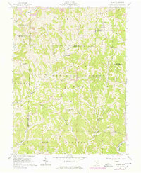
1961 Map of Dalzell
USGS Topo · Published 1978About this map
Wayne National Forest land dominates the center of this landscape, where the deeply dissected topography of Washington and Noble Counties creates a pattern of narrow ridges and winding creek valleys. Small rural centers like Dalzell and Germantown sit at key drainage junctions, while the southeastern corner is defined by the larger channel of the Little Muskingum River. This survey reveals a landscape transitioned from early agriculture to extraction, with numerous Gas Wells and active Strip Mines dotted among the steep timbered hills. For the genealogist, the map preserves several community landmarks including Masterton Cem Ch, Halls Chapel, and Liberty Cem Ch. Historic land divisions are particularly evident here, where the North Boundary Donation Tract and Congress Lands East of Scioto River intersect, marking the early federal surveying history of the Ohio Territory.
Find a feature on this map
49 named features on this map. Tap any name to fly to it.
Don’t see what you’re looking for? This feature index may not catch every label — zoom into the map to look around manually.
Map Details
Editions of this 1961 Dalzell Map
4 editions found
Other maps of this area

1903 · Macksburg
USGS Topo · 1:62,500

1904 · Marietta
USGS Topo · 1:62,500

1905 · New Matamoras
USGS Topo · 1:62,500

1905 · Macksburg
USGS Topo · 1:62,500

1906 · Saint Marys
USGS Topo · 1:62,500

1924 · St Marys
USGS Topo · 1:62,500

1924 · New Matamoras
USGS Topo · 1:62,500

1924 · Marietta
USGS Topo · 1:62,500

1926 · New Matamoras
USGS Topo · 1:62,500

1927 · Marietta
USGS Topo · 1:62,500