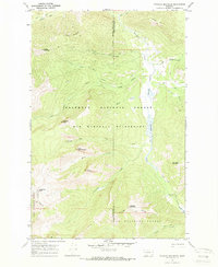
1970 Map of Danaher Mountain
USGS Topo · Published 1973About this map
The Danaher Meadows provide a natural corridor through this high mountain region where the Powell Co Lewis and Clark Co boundary meets. The landscape is defined by the drainage of Danaher Creek and its many tributaries, including White Creek and Hahn Creek, which flow through the heart of the Bob Marshall Wilderness. This 1970 field check reveals a network of primitive access routes such as the Hahn Creek Trail and Foothill Trail, which were essential for managing the remote timberlands of the Flathead National Forest.
Find a feature on this map
34 named features on this map. Tap any name to fly to it.
Don’t see what you’re looking for? This feature index may not catch every label — zoom into the map to look around manually.
Map Details
Editions of this 1970 Danaher Mountain Map
2 editions found
Other maps of this area

1902 · Ovando
USGS Topo · 1:125,000

1903 · Coopers Lake
USGS Topo · 1:125,000

1905 · Ovando
USGS Topo · 1:125,000

1955 · Choteau
USGS Topo · 1:250,000

1957 · Choteau
USGS Topo · 1:250,000

1958 · Choteau
USGS Topo · 1:250,000

1962 · Choteau
USGS Topo · 1:250,000

1968 · Spread Mountain
USGS Topo · 1:24,000

1968 · Dunham Point
USGS Topo · 1:24,000
1968 · Lake Mountain
USGS Topo · 1:24,000