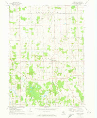
1970 Map of Dansville
USGS Topo · Published 1989About this map
The village of Dansville sits at the center of this rural Ingham County landscape, a hub of local section roads and small-scale agriculture during the late 1960s. The terrain is characterized by a network of drainage systems and wetland pockets, including Doan Creek and Deer Creek, alongside several glacial kettle lakes such as Hewes Lake and Ewers Lake. Notable local history is preserved in the distribution of family-named burial grounds like Fairview Cem, Spalding Cem, and Reeves Cem, reflecting the early settlement patterns of the surrounding townships. The presence of numerous Gravel Pits indicates the active extraction of glacial deposits, while the winding course of the Dexter Trail serves as a reminder of historical transit corridors through the region. Small hamlets like Pollok and infrastructure landmarks like the Radio Tower provide specific points of interest for those studying the mid-century development of these Michigan interior plains.
Find a feature on this map
49 named features on this map. Tap any name to fly to it.
Don’t see what you’re looking for? This feature index may not catch every label — zoom into the map to look around manually.
Map Details
Editions of this 1970 Dansville Map
3 editions found
Other maps of this area

1908 · Fowlerville
USGS Topo · 1:62,500

1909 · Mason
USGS Topo · 1:62,500

1910 · Fowlerville
USGS Topo · 1:62,500

1911 · Mason
USGS Topo · 1:62,500

1919 · Stockbridge
USGS Topo · 1:62,500

1919 · Rives Junction
USGS Topo · 1:62,500

1921 · Rives Junction
USGS Topo · 1:62,500

1922 · Stockbridge
USGS Topo · 1:62,500

1942 · Stockbridge
USGS Topo · 1:62,500

1958 · Grand Rapids
USGS Topo · 1:250,000