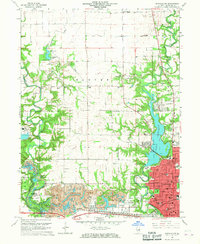
1966 Map of Danville NW
USGS Topo · Published 1967About this map
The industrial and recreational landscape of Danville and its northern outskirts unfolds along the North Fork Vermilion River. This mid-1960s survey captures the area's transition from intense resource extraction to public parkland, most notably at the Harmarttan Strip Mine and the adjacent Kickapoo State Park, where former mining pits appear as a chain of water bodies including Emerald Pond, Inland Sea, and Long Pond.
Find a feature on this map
95 named features on this map. Tap any name to fly to it.
Don’t see what you’re looking for? This feature index may not catch every label — zoom into the map to look around manually.
Map Details
Editions of this 1966 Danville NW Map
2 editions found
Other maps of this area

1899 · Danville
USGS Topo · 1:62,500

1900 · Danville
USGS Topo · 1:62,500

1931 · Fithian
USGS Topo · 1:48,000

1933 · Hoopeston
USGS Topo · 1:48,000

1936 · Potomac
USGS Topo · 1:62,500

1938 · Hoopeston
USGS Topo · 1:62,500

1943 · Fithian
USGS Topo · 1:62,500

1948 · Danville NW
USGS Topo · 1:24,000

1949 · Danville SW
USGS Topo · 1:24,000

1950 · Danville SW
USGS Topo · 1:24,000