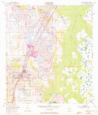
1953 Map of Davenport
USGS Topo · Published 1972About this map
Davenport serves as the primary hub of this Central Florida landscape, situated where the Seaboard Coast Line railroad cuts across the low-lying terrain. The map reveals a delicate balance of citrus groves and wetlands, with the developed grid of the town giving way to the sprawling marshlands of Reedy Creek and the Huckleberry Islands. Cultural landmarks like Little Zion Ch, Davenport Cem, and Bel Row Cem provide specific points of interest for genealogists tracing local families during the early 1950s. To the north, the smaller settlement of Loughman anchors the rail line, while an Old Railroad Grade to the east hints at earlier transport routes through the cypress swamps. This survey, updated with 1970 aerial data, captures the region just before the massive expansion of theme parks began to reshape the surrounding Florida interior.
Find a feature on this map
15 named features on this map. Tap any name to fly to it.
Don’t see what you’re looking for? This feature index may not catch every label — zoom into the map to look around manually.
Map Details
Editions of this 1953 Davenport Map
5 editions found
Other maps of this area

1953 · Dundee
USGS Topo · 1:24,000

1953 · Lake Hatchineha
USGS Topo · 1:24,000

1953 · Lake Tohopekaliga
USGS Topo · 1:24,000

1953 · Kissimmee
USGS Topo · 1:24,000

1953 · Intercession City
USGS Topo · 1:24,000

1953 · Davenport
USGS Topo · 1:24,000

1955 · Orlando
USGS Topo · 1:250,000

1957 · Orlando
USGS Topo · 1:250,000

1958 · Orlando
USGS Topo · 1:250,000

1959 · Gum Lake
USGS Topo · 1:24,000