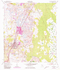
1953 Map of Davenport
USGS Topo · Published 1981About this map
Davenport and the northern edge of Haines City anchor this survey of the central Florida citrus and wetlands corridor. The landscape is defined by the contrast between organized citrus groves and the sprawling, untamed reach of Reedy Creek Swamp to the east. The Seaboard Coast Line railroad acts as a central artery, cutting a straight path through the region and connecting the rural community of Loughman to the more developed centers southward. Local history is preserved in the location of the Little Zion Ch, Davenport Cem, and Red Row Cem, which sit amidst a complex network of waterways including Horse Creek and Snell Creek. To the east, the swamp terrain reveals elevated hammocks like the Huckleberry Islands and Johnson Island, highlighting the natural barriers that shaped early settlement patterns along the Polk and Osceola county line.
Find a feature on this map
17 named features on this map. Tap any name to fly to it.
Don’t see what you’re looking for? This feature index may not catch every label — zoom into the map to look around manually.
Map Details
Editions of this 1953 Davenport Map
5 editions found
Other maps of this area

1953 · Dundee
USGS Topo · 1:24,000

1953 · Lake Hatchineha
USGS Topo · 1:24,000

1953 · Lake Tohopekaliga
USGS Topo · 1:24,000

1953 · Kissimmee
USGS Topo · 1:24,000

1953 · Intercession City
USGS Topo · 1:24,000

1953 · Davenport
USGS Topo · 1:24,000

1955 · Orlando
USGS Topo · 1:250,000

1957 · Orlando
USGS Topo · 1:250,000

1958 · Orlando
USGS Topo · 1:250,000

1959 · Gum Lake
USGS Topo · 1:24,000