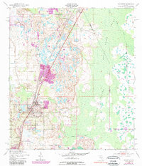
1953 Map of Davenport
USGS Topo · Published 1981About this map
The settlement of Davenport serves as a focal point in this mid-century survey of the Central Florida landscape, where the iron rails of the Seaboard Coast Line divide citrus groves from expansive wetlands. To the east, the vast Reedy Creek Swamp dominates the terrain, featuring the uniquely named Huckleberry Islands and Johnson Island rising above the marshy ground. The map details the local social fabric through landmarks like Little Zion Ch, Davenport Cem, and Bel Row Cem. Growth is evident along the northern border near Loughman and to the south in Haines City. Waterways such as Horse Creek and Snell Creek feed into Lake Davenport, illustrating the natural drainage patterns before modern development reshaped much of this region. The presence of an Old Railroad Grade near the Reedy Creek corridor provides a trace of earlier transportation routes through the Polk and Osceola county borderlands.
Find a feature on this map
18 named features on this map. Tap any name to fly to it.
Don’t see what you’re looking for? This feature index may not catch every label — zoom into the map to look around manually.
Map Details
Editions of this 1953 Davenport Map
5 editions found
Other maps of this area

1953 · Dundee
USGS Topo · 1:24,000

1953 · Lake Hatchineha
USGS Topo · 1:24,000

1953 · Lake Tohopekaliga
USGS Topo · 1:24,000

1953 · Kissimmee
USGS Topo · 1:24,000

1953 · Intercession City
USGS Topo · 1:24,000

1953 · Davenport
USGS Topo · 1:24,000

1955 · Orlando
USGS Topo · 1:250,000

1957 · Orlando
USGS Topo · 1:250,000

1958 · Orlando
USGS Topo · 1:250,000

1959 · Gum Lake
USGS Topo · 1:24,000