
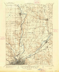
1906 Map of Dayton
USGS Topo · Published 1935About this map
Miami and Erie Canal remnants and an extensive network of electric interurban lines define the transportation landscape north of Dayton at the start of the twentieth century. This survey documents a critical period before the major flood control projects of the Miami Conservancy District, showing towns like Osborn in their original locations. The convergence of the Miami River, Stillwater River, and Mad River forms the geographic core, while the historic National Road cuts a straight path east-west through Brandt.
Find a feature on this map
66 named features on this map. Tap any name to fly to it.
Don’t see what you’re looking for? This feature index may not catch every label — zoom into the map to look around manually.
Map Details
Editions of this 1906 Dayton Map
2 editions found
Other maps of this area

1904 · Springfield
USGS Topo · 1:62,500

1904 · Dayton
USGS Topo · 1:62,500

1905 · Brookville
USGS Topo · 1:62,500

1906 · Springfield
USGS Topo · 1:62,500

1908 · Miamisburg
USGS Topo · 1:62,500

1911 · Covington
USGS Topo · 1:62,500

1913 · Waynesville
USGS Topo · 1:62,500

1914 · Troy
USGS Topo · 1:62,500

1914 · St. Paris
USGS Topo · 1:62,500

1915 · Waynesville
USGS Topo · 1:62,500