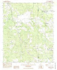
1984 Map of Deatsville
USGS Topo · Published 1985About this map
Deatsville and the surrounding borderlands of Autauga and Elmore counties are captured here in the early 1980s, revealing a landscape defined by small rural settlements and a network of minor tributaries. The Seaboard railroad line serves as a primary corridor through the north, passing near Alpha Springs and several local landmarks. The map documents numerous community focal points, including Boone Chapel, Maranatha Church, and Faith Church, alongside institutional sites like the Frank Lee Correctional Youth Center and Ingram State Technical Institute.
Find a feature on this map
38 named features on this map. Tap any name to fly to it.
Don’t see what you’re looking for? This feature index may not catch every label — zoom into the map to look around manually.
Map Details
Editions of this 1984 Deatsville Map
2 editions found
Other maps of this area

1891 · Clanton
USGS Topo · 1:125,000

1901 · Wetumpka
USGS Topo · 1:125,000

1903 · Wetumpka
USGS Topo · 1:125,000

1927 · Montgomery
USGS Topo · 1:48,000

1930 · Montgomery
USGS Topo · 1:62,500

1953 · Montgomery
USGS Topo · 1:250,000

1956 · Montgomery
USGS Topo · 1:250,000

1957 · Montgomery
USGS Topo · 1:250,000

1957 · Autaugaville
USGS Topo · 1:62,500

1958 · Montgomery
USGS Topo · 1:62,500