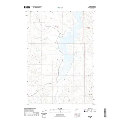
2020 Map of Decker
USGS Topo · Published 2020About this map
The Tongue River and its expansive Tongue River Reservoir anchor this 2020 landscape in Big Horn County, defining the hydrology of a region where high plains meet broken breaks. The small settlement of Decker sits in the southwestern portion of the map, served by Decker Rd and Co RD 314. The terrain is deeply dissected by numerous drainages including Pearson Cr, Pond Cr, and Deer Cr, which feed into the central waterway. To the southeast, the Badger Hills rise above the drainage of Badger Cr, illustrating the complex topography typical of the Montana-Wyoming borderlands. The map also identifies several specific groundwater sources such as the 08S40E34ACCA01 Spring, providing a precise record of water resources critical to the local ranching and agricultural economy.
Find a feature on this map
29 named features on this map. Tap any name to fly to it.
Don’t see what you’re looking for? This feature index may not catch every label — zoom into the map to look around manually.
Map Details
Editions of this 2020 Decker Map
This is the sole edition of this map. No revisions or reprints were ever made.
Other maps of this area
1909 · Sheridan
USGS Topo · 1:125,000
1911 · Sheridan
USGS Topo · 1:125,000
1954 · Hardin
USGS Topo · 1:250,000
1955 · Sheridan
USGS Topo · 1:250,000
1957 · Hardin
USGS Topo · 1:250,000
1958 · Hardin
USGS Topo · 1:250,000
1958 · Sheridan
USGS Topo · 1:250,000
1962 · Sheridan
USGS Topo · 1:250,000
1967 · Holmes Ranch
USGS Topo · 1:24,000
1967 · Tongue River Dam
USGS Topo · 1:24,000