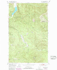
1952 Map of Deep Lake
USGS Topo · Published 1986About this map
Mining operations and remote forest camps define this pocket of the Colville National Forest during the mid-20th century. High elevations such as Sherlock Peak and Baldy Mountain overlook a landscape marked by early extractive industries, including the Thompson Iron Mine and the Maki Mine. These sites, along with various Prospect markings, suggest a period of active mineral exploration across the Stevens and Pend Oreille county line.
Find a feature on this map
33 named features on this map. Tap any name to fly to it.
Don’t see what you’re looking for? This feature index may not catch every label — zoom into the map to look around manually.
Map Details
Editions of this 1952 Deep Lake Map
4 editions found
Other maps of this area

1929 · Colville
USGS Topo · 1:125,000

1933 · Colville
USGS Topo · 1:125,000

1934 · Metaline
USGS Topo · 1:125,000

1942 · Metaline
USGS Topo · 1:125,000

1952 · Spirit
USGS Topo · 1:24,000

1952 · Deep Lake
USGS Topo · 1:24,000

1952 · Leadpoint
USGS Topo · 1:24,000

1952 · Boundary
USGS Topo · 1:24,000

1952 · Aladdin
USGS Topo · 1:24,000

1958 · Sandpoint
USGS Topo · 1:250,000