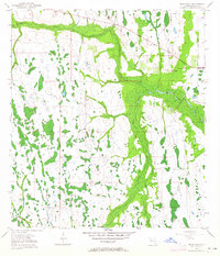
1953 Map of Deer Park
USGS Topo · Published 1964About this map
Deer Park serves as the primary point of settlement in this part of Osceola County, located along the route of Highway 192. The landscape is dominated by a complex network of wetlands and seasonal watercourses, where the wide floodplains of Bull Creek and Crabgrass Creek converge. These drainages define the local topography, with numerous small hammocks and depressions scattered throughout the terrain.
Find a feature on this map
14 named features on this map. Tap any name to fly to it.
Don’t see what you’re looking for? This feature index may not catch every label — zoom into the map to look around manually.
Map Details
Editions of this 1953 Deer Park Map
5 editions found
Other maps of this area

1953 · Deer Park NE
USGS Topo · 1:24,000

1953 · Holopaw SE
USGS Topo · 1:24,000

1953 · Deer Park SE
USGS Topo · 1:24,000

1953 · Kenansville
USGS Topo · 1:24,000

1953 · Deer Park NW
USGS Topo · 1:24,000

1953 · Kenansville NE
USGS Topo · 1:24,000

1953 · Deer Park
USGS Topo · 1:24,000

1953 · Holopaw
USGS Topo · 1:24,000

1953 · Lake Marian NE
USGS Topo · 1:24,000

1955 · Orlando
USGS Topo · 1:250,000