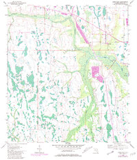
1953 Map of Deer Park
USGS Topo · Published 1981About this map
Deer Park serves as the primary focal point of this Central Florida landscape, situated within a vast network of wetlands and creek systems. The terrain is defined by the winding paths of Jane Green Creek and Bull Creek, which navigate through numerous small ponds and marshy depressions typical of Osceola County. The settlement itself is modest, featuring a Lookout Tower that stands as a notable landmark overlooking the surrounding flatlands.
Find a feature on this map
13 named features on this map. Tap any name to fly to it.
Don’t see what you’re looking for? This feature index may not catch every label — zoom into the map to look around manually.
Map Details
Editions of this 1953 Deer Park Map
5 editions found
Other maps of this area

1953 · Deer Park NE
USGS Topo · 1:24,000

1953 · Holopaw SE
USGS Topo · 1:24,000

1953 · Deer Park SE
USGS Topo · 1:24,000

1953 · Kenansville
USGS Topo · 1:24,000

1953 · Deer Park NW
USGS Topo · 1:24,000

1953 · Kenansville NE
USGS Topo · 1:24,000

1953 · Deer Park
USGS Topo · 1:24,000

1953 · Holopaw
USGS Topo · 1:24,000

1953 · Lake Marian NE
USGS Topo · 1:24,000

1955 · Orlando
USGS Topo · 1:250,000