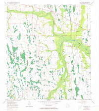
1953 Map of Deer Park
USGS Topo · Published 1973About this map
Deer Park serves as the primary point of settlement in this Osceola County landscape, situated along a transportation corridor where local hydrology dictates the pattern of the land. The map reveals a complex network of wetlands and watercourses, including the meandering paths of Crabgrass Creek and Bull Creek. These streams flow through an area marked by numerous depressions and small water bodies like Clay Lake and Billy Lake.
Find a feature on this map
11 named features on this map. Tap any name to fly to it.
Don’t see what you’re looking for? This feature index may not catch every label — zoom into the map to look around manually.
Map Details
Editions of this 1953 Deer Park Map
5 editions found
Other maps of this area

1953 · Deer Park NE
USGS Topo · 1:24,000

1953 · Holopaw SE
USGS Topo · 1:24,000

1953 · Deer Park SE
USGS Topo · 1:24,000

1953 · Kenansville
USGS Topo · 1:24,000

1953 · Deer Park NW
USGS Topo · 1:24,000

1953 · Kenansville NE
USGS Topo · 1:24,000

1953 · Deer Park
USGS Topo · 1:24,000

1953 · Holopaw
USGS Topo · 1:24,000

1953 · Lake Marian NE
USGS Topo · 1:24,000

1955 · Orlando
USGS Topo · 1:250,000