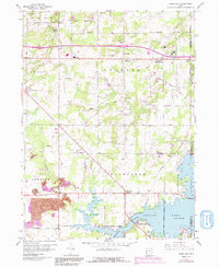
1960 Map of Deerfield
USGS Topo · Published 1991About this map
Berlin Lake dominates the southeast corner of this landscape, its fluctuating shoreline framing the small settlement of Fewtown and the Hayden Cem. The map illustrates a rural transition where traditional township centers like Palmyra and Deerfield intersect with mid-century industrial markers, including a Strip Mine and a large Claypit near the Kilns. Local history is deeply etched into the terrain through a high density of small burial grounds such as Robinson Cem, Mottown Cem, and Whippoorwill Cem, often tucked away near established family-named roads.
Find a feature on this map
53 named features on this map. Tap any name to fly to it.
Don’t see what you’re looking for? This feature index may not catch every label — zoom into the map to look around manually.
Map Details
Editions of this 1960 Deerfield Map
4 editions found
Other maps of this area

1906 · Ravenna
USGS Topo · 1:62,500

1908 · Warren
USGS Topo · 1:62,500

1908 · Ravenna
USGS Topo · 1:62,500

1909 · Alliance
USGS Topo · 1:62,500

1909 · Lisbon
USGS Topo · 1:62,500

1950 · Cleveland
USGS Topo · 1:250,000

1951 · Canton
USGS Topo · 1:250,000

1952 · Lake Milton
USGS Topo · 1:24,000

1952 · Alliance
USGS Topo · 1:24,000

1952 · Damascus
USGS Topo · 1:24,000