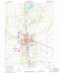
1960 Map of Delaware
USGS Topo · Published 1974About this map
Ohio Wesleyan University and the Delaware city center sit at the heart of this mid-century landscape, bisected by the Olentangy River. The map documents a period of transition as the town's urban footprint expands, shown in purple revision tints, while the surrounding townships of Troy, Brown, and Berlin remain largely agricultural. The river valley is a focal point for infrastructure and recreation, featuring the Delaware Reservoir and the adjacent Delaware Reservoir Wildlife Area to the north.
Find a feature on this map
58 named features on this map. Tap any name to fly to it.
Don’t see what you’re looking for? This feature index may not catch every label — zoom into the map to look around manually.
Map Details
Editions of this 1960 Delaware Map
3 editions found
Other maps of this area

1901 · Dublin
USGS Topo · 1:62,500

1902 · Westerville
USGS Topo · 1:62,500

1903 · Dublin
USGS Topo · 1:62,500

1904 · Westerville
USGS Topo · 1:62,500

1915 · Marengo
USGS Topo · 1:62,500

1924 · Delaware
USGS Topo · 1:62,500

1925 · Delaware
USGS Topo · 1:62,500

1943 · Marengo
USGS Topo · 1:62,500

1944 · Delaware
USGS Topo · 1:62,500

1950 · Marion
USGS Topo · 1:250,000