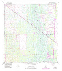
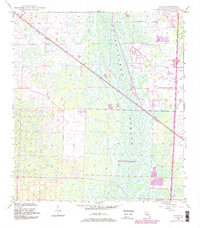
1945 Map of Delta
USGS Topo · Published 1984About this map
The Loxahatchee Slough dominates this mid-century Florida landscape, appearing as a wide corridor of wetlands and intermittent water that separates emerging residential developments from the undeveloped interior. This 1945 survey, updated with revisions in 1983, shows the northward expansion of West Palm Beach and the organized street grids of Palm Beach Gardens. Transportation infrastructure defines the area's growth patterns, with the diagonal line of the Seaboard railroad cutting across the slough towards the small settlement of Delta. To the east, modern transit is represented by the Floridas Turnpike and its Toll Road components, including the Tollgate at Interchange 44. This map preserves the transition from a swamp-dominated wilderness to a structured suburban environment, noted by the presence of a remote Landing Strip and multiple golf courses carved out of the natural terrain.
Find a feature on this map
14 named features on this map. Tap any name to fly to it.
Don’t see what you’re looking for? This feature index may not catch every label — zoom into the map to look around manually.
Map Details
Editions of this 1945 Delta Map
6 editions found
Other maps of this area

1945 · Delta
USGS Topo · 1:24,000

1946 · Riviera Beach
USGS Topo · 1:24,000

1946 · Palm Beach Farms
USGS Topo · 1:24,000

1946 · Palm Beach
USGS Topo · 1:24,000

1948 · Rood
USGS Topo · 1:24,000

1948 · Jupiter
USGS Topo · 1:24,000

1949 · Rood
USGS Topo · 1:24,000

1949 · Palm Beach Farms
USGS Topo · 1:24,000

1949 · Riviera Beach
USGS Topo · 1:24,000

1950 · Jupiter
USGS Topo · 1:24,000