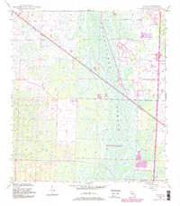
1945 Map of Delta
USGS Topo · Published 1984About this map
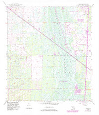
The Loxahatchee Slough dominates this mid-century landscape, appearing as a complex network of wetlands and wooded hammocks before extensive drainage and development. The Seaboard railroad cuts a sharp diagonal through the terrain, passing through the small siding of Delta, which stands in quiet contrast to the emerging residential and commercial hubs nearby. By the early 1980s, significant changes arrived in the form of Palm Beach Gardens and the northward expansion of West Palm Beach. This map documents the arrival of major infrastructure, specifically Floridas Turnpike, including its Tollgate and Interchange 44. The transition from a wilderness-dominated slough to a structured urban corridor is evident in the presence of various golf courses and a Landing Strip, signaling the region's rapid evolution into a recreational and transit-oriented gateway.
Find a feature on this map
15 named features on this map. Tap any name to fly to it.
Don’t see what you’re looking for? This feature index may not catch every label — zoom into the map to look around manually.
Map Details
Editions of this 1945 Delta Map
6 editions found
Other maps of this area

1945 · Delta
USGS Topo · 1:24,000

1946 · Riviera Beach
USGS Topo · 1:24,000

1946 · Palm Beach Farms
USGS Topo · 1:24,000

1946 · Palm Beach
USGS Topo · 1:24,000

1948 · Rood
USGS Topo · 1:24,000

1948 · Jupiter
USGS Topo · 1:24,000

1949 · Rood
USGS Topo · 1:24,000

1949 · Palm Beach Farms
USGS Topo · 1:24,000

1949 · Riviera Beach
USGS Topo · 1:24,000

1950 · Jupiter
USGS Topo · 1:24,000