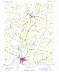
1944 Map of Denton
USGS Topo · Published 1976About this map
The Choptank River meanders through the heart of Caroline County, serving as a primary corridor for navigation and industry during the mid-20th century. While Denton serves as the focal point with its urban expansion and rail connections, the surrounding landscape is defined by its historic landings such as Brick-Wall Landing and Smith Landing. The agricultural character of the region is evident in the presence of the County Farm and local processing sites like Sewell Mills.
Find a feature on this map
38 named features on this map. Tap any name to fly to it.
Don’t see what you’re looking for? This feature index may not catch every label — zoom into the map to look around manually.
Map Details
Editions of this 1944 Denton Map
5 editions found
Other maps of this area

1899 · Dover
USGS Topo · 1:125,000

1905 · Denton
USGS Topo · 1:62,500

1905 · Barclay
USGS Topo · 1:62,500

1906 · Dover
USGS Topo · 1:125,000

1918 · Harrington
USGS Topo · 1:62,500

1920 · Dover
USGS Topo · 1:125,000

1926 · Wyoming
USGS Topo · 1:48,000

1930 · Wyoming
USGS Topo · 1:62,500

1931 · Wyoming
USGS Topo · 1:62,500

1944 · Denton
USGS Topo · 1:31,680