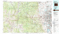
1983 Map of Denver West
USGS Topo · Published 1988About this map
The Front Range of the Rockies meets the expanding urban corridor of the western Denver metro area in this early 1980s landscape. From the high peaks of the Continental Divide at Grays Peak and Mount Evans, the terrain descends sharply into historical mining districts around Central City and Black Hawk. The transition from mountain wilderness to suburban development is marked by the distinct Hogback ridge and prominent landforms like North Table Mtn.
Find a feature on this map
104 named features on this map. Tap any name to fly to it.
Don’t see what you’re looking for? This feature index may not catch every label — zoom into the map to look around manually.
Map Details
Editions of this 1983 Denver West Map
2 editions found
Other maps of this area

1889 · Leadville
USGS Topo · 1:125,000

1890 · East Denver
USGS Topo · 1:125,000

1891 · Leadville
USGS Topo · 1:125,000

1893 · Platte Canyon
USGS Topo · 1:125,000

1894 · Castle Rock
USGS Topo · 1:125,000

1899 · West Denver
USGS Topo · 1:125,000

1902 · Greeley
USGS Topo · 1:125,000

1902 · Boulder
USGS Topo · 1:62,500

1903 · Georgetown
USGS Topo · 1:62,500

1904 · Niwot
USGS Topo · 1:62,500